There are three start points, starting from near my house and working in though Brent. They are:
11:00 am Kingsbury tube station
11:45 am Gladstone Park railway bridge (at the south end of Parkside NW2)
12:05 pm Queens Park Station car park
If you'd like to join somewhere else on the route described below, tell me and I'll see if it can be arranged.
 |
| Under-construction segregated cycle tracks. Larger map here. |
There's no infrastructure to speak of on the ride before reaching Queens Park, though just past Gladstone Park a pile of stuff is encountered in Park Avenue North, which I suspect is the first sign of construction of Quietway 3 in Brent.

Quietway 3 will run from Regent's Park to Gladstone Park in its first phase, with hopefully an extension across the north Circular towards Wembley and Harrow later (though that will be in the lap of the next Mayor).
Near the final pick-up point at Queens Park Station we will pause to have a look at the Brent section of Carlton Vale, with a copy of the plans for semi-segregated cycle tracks that I have in my possession. These have not yet been put to public consultation, so this is a good stage to feed suggestions for improvement back to the Brent Council.
The next objective of the ride is to look at the location of the future East-West Superhighway in Hyde Park. Unfortunately to get there is to try to pass through a terribly bike-impermeably part of London, through the need to cross the Westway, Grand Union Canal and Paddington railway corridor. There is no legal way through here north-south for cyclists between Royal Oak (Lord Hill's Bridge) and the Edgware Road, both of which are most unpleasant roads – a gap of 1km. If the East West Superhighway is extended to the A40, as planned, and if Westminster build their Quietway network, this barrier might one day be surmounted. But it is not clear to me how it will be, or if the planners of the grid have realised what problem this is.
The best that we can do on Sunday is to get off and walk. After passing through the pedestrain-only underpass at Porteus Road, we reach the newpedestrain-only bridge across the Grand Union Canal at the Paddington Central development.

That such a poor piece of pedestrian infrastructure was created so recently in such an important place is quite shocking. Forget about not being bale to cycle across it: how could a wheelchair user negotiate a corner like this?

Proceeding via the pedestrain-only waterside and primitively-cobbled path leading to London Road by Paddington Station, we will cycle to Hyde Park. There we see signs of action.
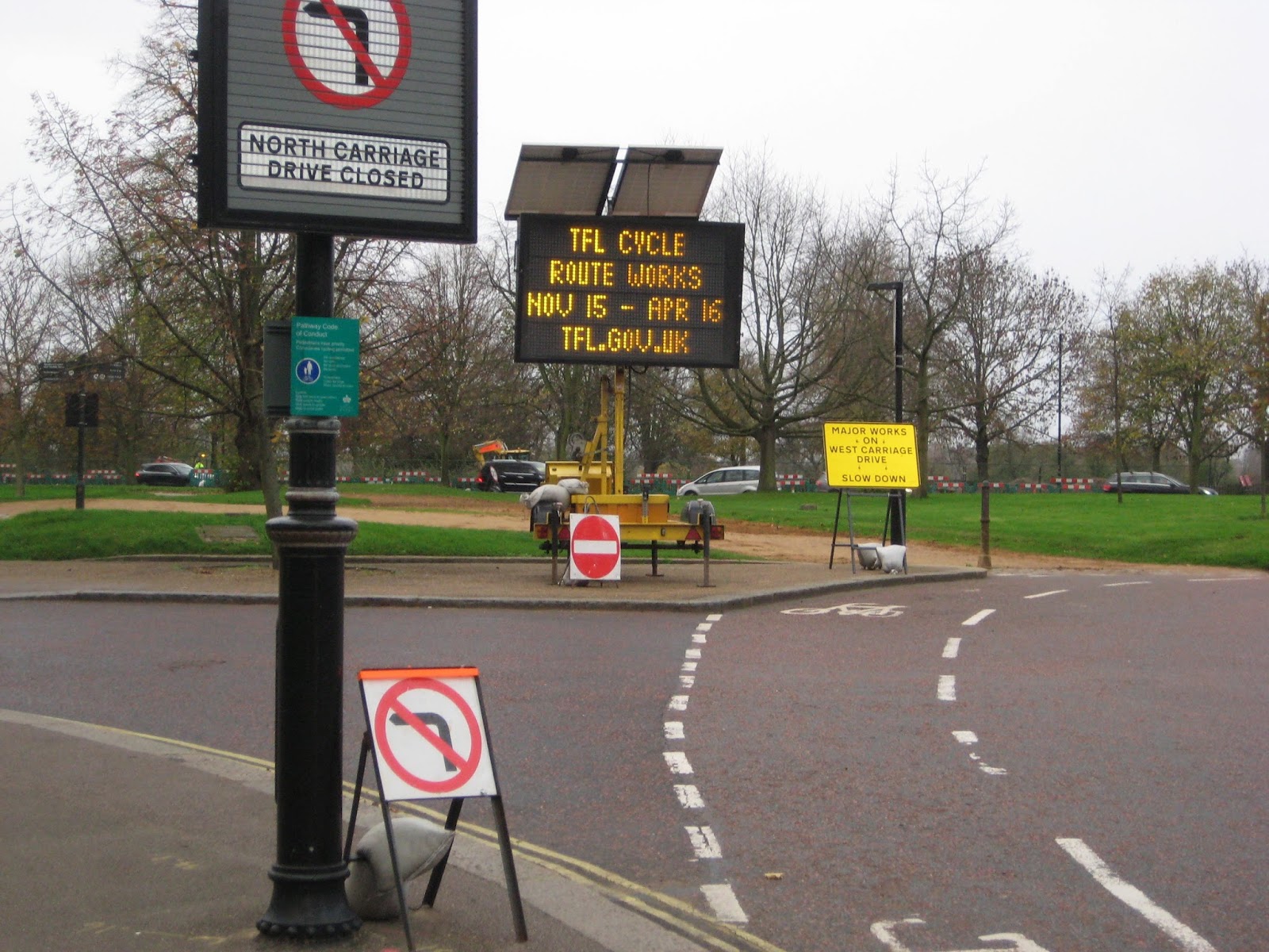

The E-W superhighway will go via the West and South Carriage Drives, which we will follow. This routing is clearly intended to take pressure off the shared (separated) paths Rotten Row and Broad Walk, though I doubt how successful this strategy will be, as Broad Walk and North Carriage Drive will represent a shorter route. We will then follow an old London Cycle Network route, sadly under-engineered, which was originally known as the Ambassadors' Route when created in the early 1980s (it features prominently in this film). This takes us to Pimloco where we can discover what has been built of the north end of Cycle Superhighway 5 in Vauxhall Bridge Road. This is where things start to get impressive.

This sets the pattern for what we will see on the rest of the ride. Here we have a 4m wide two-way cycle track separated by low kerbs from both pavement and road, clearly set-out. We'll be able to observe how, for example, the pedestrian crossings like this one work. This continues to the crossing of the Thames at Vauxhall Bridge.


Though this is not on the most direct route between Elephant and Castle and Blackfriars Road, the cycle track is again impressively implemented. It leads into similar engineering still being built on the west side of Blackfriars Road, via a signalised crossing of the St George's Circus roundabout. We will be able to judge the efficiency of these junctions for cyclists. My impression was that they are good. By this stage in the ride we have already seen probably more of the low-level cycle signals than has anybody else in the UK. These fantastically sensible features have only just been approved for use, and Transport for London are rolling them out on these tracks.

The track is not yet constructed on Blackfriars Bridge or the slip road off it, but we can see where it will be. The Thames was looking quite choppy when I took these photos on Wednesday.

We will then find, I hope, that we can then cycle a substantial section of the Embankment Superhighway going westwards that is not yet officially open. Here are the works between Blackfriars and Waterloo Bridges.

And here is the section already in use, approaching Westminster Bridge, with the wide segregating island designed so that coach parties can congregate on it without spilling into the track, and chamfered kerb to minimise the chance of pedal-strike. This has already become an 'iconic' view of London, to those of us of a kerb-nerd disposition.

Parliament Square is as awful as always; work on the cycle crossings here has not yet started. We will head up now through the West End, as best we can, showing where is another of the serious gaps in the infrastructure that is in the City of Westminster's court to solve. Charing Cross Road is a disaster-area that desperately needs complete re-planning including Space for Cycling, or most of the traffic removed. It is a disaster equally for those on bikes as those stuck in the permanent queues in buses and taxis. It just doesn't work as it is.

We reach more civilised territory as soon as we cross the border into Camden. The Borough of Camden deserves huge credit for, over the last twenty years, rationally re-planning and upgrading its traffic network, particularly in the south of the borough, with an emphasis on removing unnecessary traffic from residential (and some business) neighbourhoods, and facilitating cycling. I have covered the history of Camden's cycle network extensively on this blog. Particularly deserving of credit is the Camden Cabinet Member for the Environment, their roads supremo, Councillor Phil Jones, who has lead a serious expansion of the segregated cycle network in the borough (which was already the only one deserving the name in London), using the money made available by Transport for London under Mayor Boris Johnson's cycling programme, and, particularly, has bitten the bullet and ordered the doubling of capacity of the east-west segregated cycle link through Bloomsbury (the old London Cycle Network route 0, or the Seven Stations link), so brining to the originally-intended standard the link planned and lobbied for by Paul Gannon, Paul Gasson, myself, and other members of Camden Cycling Campaign in the early 2000s. I need also to mention that the current members of CCC have campaigned energetically for this outcome.
We will see on our ride how this work is progressing. The original two-way cycle track on the north side of the road is being converted to a one-way track eastbound within the same width, and a new westbound track is being constructed using semi-segregating Orcas (already used in Waltham Forest and planned for use on Carlton Vale in Brent). Hence the cycle capacity of this incredibly popular link is being doubled, through a whole lane of motor traffic being removed and the whole of the corridor being converted to one-way operation for motor traffic. Moreover, the motor flows are being opposed on opposite sides of Gower Street, so removing the corridor as a rat-run alternative to Euston Road entirely. This is exactly how the Dutch so frequently use one-way working for motors in dense city centres to eliminate through traffic, and it is great to see a London borough applying this concept. The reduction in traffic on the corridor and simplification of the whole system should remove the junction problems that have existed on this route in its previous layout. The separation of the eastbound and westbound flows of cyclists will remove the risk of cycle-cycle collisions in the old confined space. Pedestrian facilities are being improved as well. It's a win all round.

There is a major backlash (mostly from the black cab lobby) against the scheme already and it is important that Camden Council recieves lots of support for the scheme. As Camden Cyclists state on their website,
If you like the scheme when you have tried it, tweet about it with #taviplace or send an e-mail to Camden Council: torringtontavistocktrial@camden.gov.uk to help ensure that the supporting voices outweigh those of the objectors – who will undoubtedly be many. ‘Winning the peace’ also entails all who use the new scheme riding legally and courteously so as to maintain the respect of local residents.

Not everything Camden has done for cyclists in recent years has been quite so clever. After experiencing this (unfinished) project we head up to Kings Cross and St Pancras, and one curious thing we experience is the Pancras Road tunnel under the railway (below) where the cycle lane is the bit bewtween the solid white line and the segregating island, coming into collision with the left-turning stream of traffic. The bit between the segregating island and the pavement is... wait for it... a taxi lane! And the taxi drivers have the nerve to be ungrateful to Camden now over Tavistock Place!

In the northern part of Pancras Road Camden are doing better, with new stepped cycle tracks, which we will also experience, before finding our way to the northbound Royal College Street cycle track, which has had some subtle improvements since I last posted about it when first it opened. We will then follow the route along Pratt Street and Delancey Street that will be going ahead for upgrade to two-way cycling in the next phase of Camden's Cycle Grid programme. From there the old LCN route on Gloucester Avenue and King Henry's Road takes us towards Swiss Cottage (this notorious gyratory also programmed to be reformed for the construction of CS 11 up the Finchley Road next year), and thence back towards the ride's starting points in Brent.
I think the ride will give a good overview of how a proper cycle network for London is now starting to emerge, after many years of hard campaigning for it by a great many people. For me, as I explained recently in a long, personal post, the story began in the late 1990s with the campaign in Camden for the original Royal College Street segregated cycle track (now replaced), a pioneering feature in London then, and then the campaign for the Seven Stations Link. These pieces of infrastructure I believe established and demonstrated in London for the first time the principles that we are now seeing rolled out on a much larger scale in the new Superhighways. Boris Johnson recently commented in the London Assembly that 'Virtually every cabinet member has ticked me off for the Cycle Superhighways', and I think this shows what a fundamentally unpopular course in the British political culture he has chosen to follow here, and how much credit he deserves for doing something really rather good, that will undoubtedly be the major legacy of his mayoralty. Also deserving of credit is his Cycling commissioner, Andrew Gilligan, for pushing recalcitrant officials and recalcitrant boroughs into action on the Mayor's cycling programme. When he was appointed in 2013, many wondered if, as a journalist, if he was appropriately-qualified for the job, but I commented at the time that his skills as a propagandist might just be those most needed in the role, and I think I was right.
It's a fragile legacy. The next mayor has it in his or her power to get on with the programmes, fill in the worst gaps (for example north-south across the West End), connect up all the segregated Superhighways, extend them into all the outer boroughs, build more mini-Hollands like the successful Walthamstow one, break the major barriers in Outer London like the North Circular, and enhance the quality of the Quietways. Or he or she has it in their power to effectively abort the programme and leave the lovely pieces of engineering that we are now seeing in their glistening newness as sad stubs and monuments to what might have been, a transport revolution never delivered. As Cyclists in the City has recently commented, though the Green and Liberal Democrat candidates for Mayor in 2016 (who are not likely to win) seem highly committed to continuing the cycling programme, the commitment of the Conservative and Labour candidates, Zac Goldsmith and Sadiq Kahn respectively, is really not very clear from what either of them has said so far. It's going to be another close race for Mayor in 2016, and the vote of cyclists is going to make a difference. I invite the two of them to commit clearly now to completing the current programmes and thereafter to further major expansion of high-quality cycling infrastructure, maintaining at least the current level of expenditure on cycling in London.
In the shorter term, I invite you, if you can make it, to my tour of London's developing cycle network on Sunday.


